A Path of Memory and Future
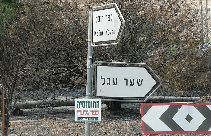 Road signs of Israel National Trail part 1 pointing at Kfar Juval near Mount Hermon | Photo: Wikimedia Commons by Yoav Dothan
In his popular novel “To the end of the Land,” Israeli author David Grossman writes about Ofer, a young soldier. Ofer had the misfortune of war breaking out when he was only days away from release from the army. It was bad news for Ora his mother too. In order to distract herself from worrying about her son and take her mind off things, Ora decides to walk the Israel National Trail. On her travels she does everything to avoid contact with people who might cause her anxiety by updating her with the news. Instead she tries to focus on the beauty around. However, as is the case in Israel, she frequently comes across various monuments dedicated to soldiers who had been killed in previous wars. This story of a woman on her adventures on the National Trail, has become just one of many.
“Every year thousands of Israelis take to the now famous Israel National Trail”

Israeli author David Grossman in Prague, 2018 | Photo: Wikimedia Commons by Jindřich Nosek (NoJin)
Every year thousands of Israelis take to the now famous Israel National Trail, which not only is marked on Google Maps, but was even recognised by National Geographic for being one of the world’s best hiking trails. Waxing lyrical, the world’s most reputable nature institution states: “Beyond the immense sense of history and breaking news, the Israel National Trail powerfully connects to something that often gets lost in all the headlines—the sublime beauty of the wilderness of the Middle East. The trail delves into the grand scale of biblical landscapes as well as the everyday lives of the modern Israeli.”
Stretching over a thousand kilometres from Kibbutz Dan in the North to the Red Sea resort of Eilat in the south, the trail weaves its way through diverse scenery, crossing valleys, deserts, fields and mountains. Some Israelis tackle the trail in one sweep which can take about two months. Others, put on their hiking shoes and do it a portion at a time. Some even do it over a few years.
The path attracts not only the young, but also families and pensioners too. Sometimes the hiking is a community effort where groups of individuals come together from the same town, or the same company, or any other field of interest. One popular way to do the trail is to join the Gourmet Group, in which hikers seek tasty and local delicacies from the plethora of Israel’s minorities as well as various cuisine from Jewish people who have come from all over the world to make their home in Israel. After completing the trail, some people are compelled to publish books of their experience. These books are not just informative, they also serve as inspiration for anyone toying with the idea of doing the trail in the future.
The trail is marked by the now famous vertical blue, orange and white signs which distinguish the National Trail from the other trails which traverse all over the country. White is on the right of the sign, blue in the middle and orange on the left. The white represents the snowy Hermon in the north, the blue the Mediterranean Sea in the west and the orange the desert in the South. When the white line finds itself as the top line in the sign, it means that the path points north -toward the Hermon. When the orange line is at the top, the direction is south. This clever marking helps hikers not to lose their way.
“Another unique initiative are the “libraries” placed along the way”
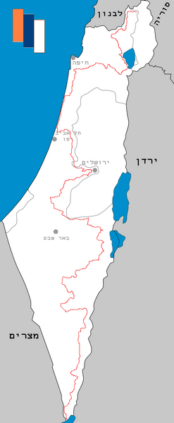
Israel Natiopnal Trail Map | Photo: Wikimedia Commons by Ori~
Another unique initiative are the “libraries” placed along the way. The brainchild of the Nature and Parks Society, the 16 libraries are little metal boxes marked with the trail sign in which there is enough space to place about 20 books. Hikers are encouraged to take the books, read them and when they are done reading them, leave them at the next “library.” Many people bring books with them that they don’t want any more, and leave them in the libraries. Hikers can also get a trail “passport” which the Society for the Protection of Nature stamps intermittently along the way.
Due to the scorching sun of the summers and the flash floods of the winter, the trail is best taken on in spring and autumn. Yet even in those comparatively mild seasons, hikers can be struck by the weather. To avoid any possibility of dehydration they cache supplies of food and water in caches at designated points before beginning the hike. They can also pay a small fee for supplies to be delivered. Then there are the “trail angels.” These are just good ordinary folk who store cool bottles of mineral water just because they want to help out. Help is everywhere along the way and in many forms. There are websites updating hikers, and social media pages offering advice, interactive maps, weather reports, and updates about water holes and food supplies. Many people also offer free hospitality and some kibbutzniks leave their house keys for hikers to stay for a few days in exchange for helping out at the kibbutz.
The idea of a long-distance national trail began to shape forty years ago when hiker and nature journalist Avraham Tamir returned from his adventures in the Appalachian Trail. When he pitched his idea of a national trail in Israel to the nature societies and organisations, many people were against it. They claimed there were already over 15,000 km of trails in Israel, so this would be superfluous. Besides, they said, no one in their right mind would ever want to hike all the way from Dan to Eilat! Eventually Tamir found enthusiasm. Once the suggested trail was on paper, Israel’s nature magazine and the Army Radio organised a project of volunteers to try out the planned trail. They divided them all into over 60 groups. Each group was to try out the suggested segments of the trail. The positive reports were overwhelming. The trail was a raging success. In 1995 the late President Ezer Weizmann inaugurated the trail and put it on the map.
Like everything else in Israel, the planners of the trail also needed to be flexible. In 2003, just eight years after the inauguration, part of the path had to be rerouted. Israel was building a toll highway which would open up the costal road and ease traffic traveling up and down the country. The toll road would have to cut through the trail. It was decided that a diversion from the hills of Samaria to the coast would solve the problem. The road was essential and there was beauty on the coast for hikers to see!
The Israel National Trail is so much more than a nature trail. It is a path which connects Israelis deeply to their history, which is one of loss and gain, of sweat and tears, but also a path of redemption. Venturing on the trail creates community. Many say that it enhanced the importance of memory but also created an awareness of the present and the need to be thankful. Thus, like most things in Israel, there is more to this than meets the eye.
Why Israel? by Rev. Willem Glashouwer
Order the book